Weather window shopping by BenNollWeather

An always-updating gallery of operational weather graphics

Latest posts

The 10 newest posts from @BenNollWeather.

With El Niño’s massive cell of rising air bubbling over the Pacific, the U.S. looks poised for an active November.

I’m especially interested in late November, when an MJO pulse could constructively interfere with El Niño around Thanksgiving, increasing storm chances 🌀

  • 189 likes
  • 31 reposts
  • 8 replies
  • 9,876 views
View on X

Not a whole lot of unusual cold to be found across North America into mid-November.

An El Niño-fueled area of low pressure near Alaska's Aleutian Islands will continuously flood the continent with mild, Pacific air.

  • 221 likes
  • 35 reposts
  • 10 replies
  • 16,079 views
View on X

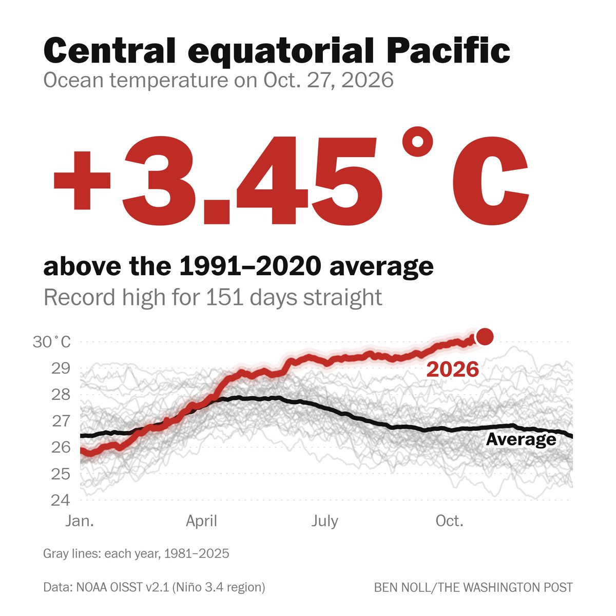
This El Niño has now set ocean temperature records for 150+ days straight.

Average temperatures in the central equatorial Pacific Ocean have reached 86.4°F (30.2°C), while maximum temperatures have climbed to 88.8°F (31.6°C).

But this El Niño is about more than just numbers 🧵

This El Niño has now set ocean temperature records for 150+ days straight.
  • 471 likes
  • 170 reposts
  • 12 replies
  • 18,183 views
View on X

Through next week, copious amounts of moisture will be carried cross-country by a storm expected to push ashore in Southern California this weekend.

Atmospheric moisture could reach 3x to 4x normal as this system crosses the U.S., bringing potential flooding and severe storms.

  • 119 likes
  • 26 reposts
  • 1 reply
  • 8,517 views
View on X

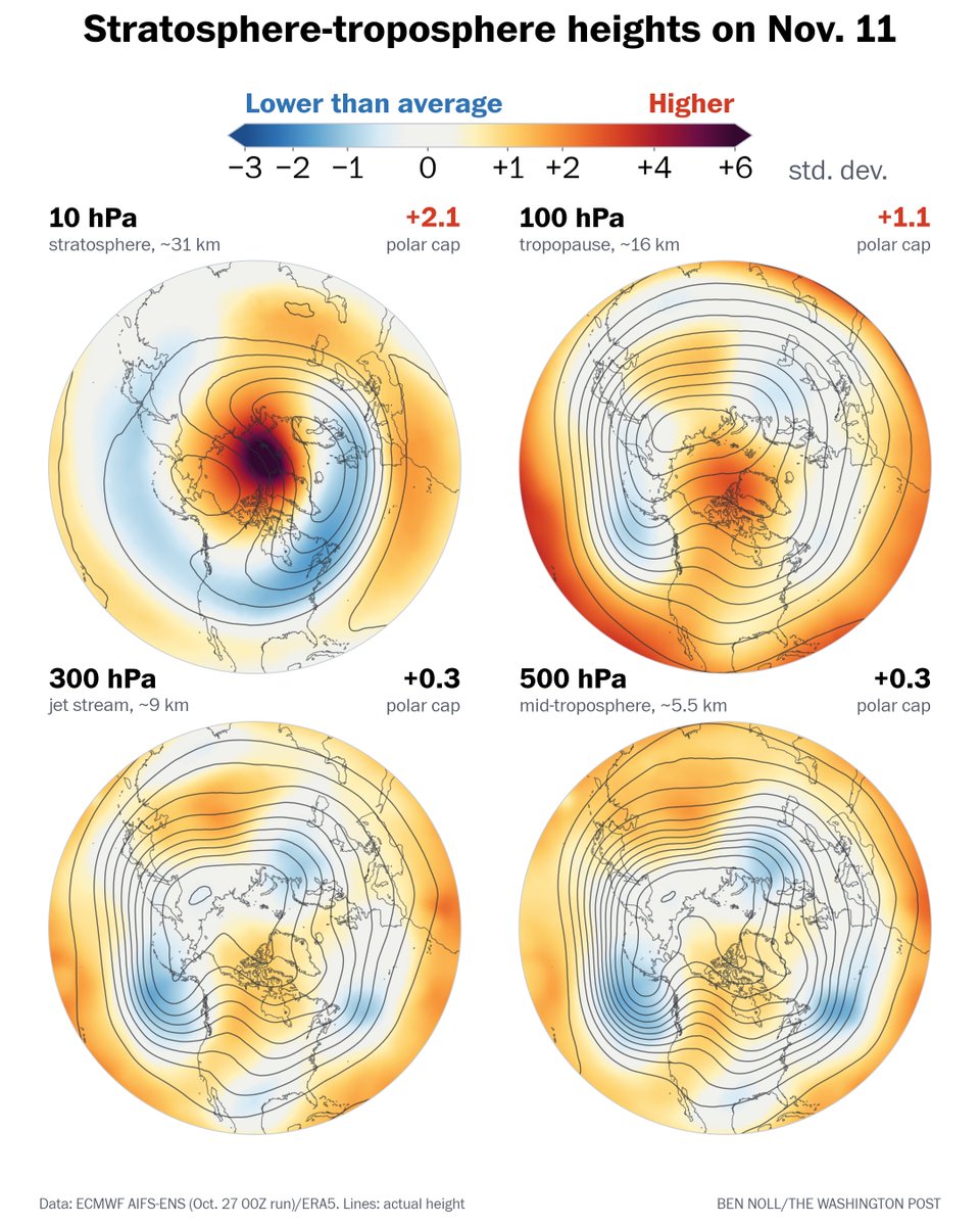
By mid-November, the stratospheric polar vortex will be disrupted. Will its cold air be unleashed across the hemisphere?

That currently looks unlikely, with stratospheric patterns not forecast to connect well with the mid-troposphere — but impacts could still emerge later.

By mid-November, the stratospheric polar vortex will be disrupted. Will its cold air be unleashed across the hemisphere?
  • 129 likes
  • 22 reposts
  • 9 replies
  • 18,304 views
View on X

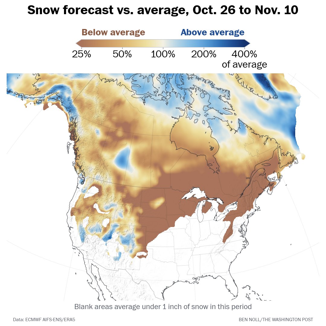
Looking ahead to November, exceptional warmth is forecast across Canada as low pressure near Alaska’s Aleutian Islands blows in mild Pacific air — a hallmark of El Niño.

Because of this lack of cold air, snowfall advance will be much below average across North America.

Looking ahead to November, exceptional warmth is forecast across Canada as low pressure near Alaska’s Aleutian Islands blows in mild Pacific air — a hallmark of El Niño.
  • 124 likes
  • 18 reposts
  • 3 replies
  • 12,316 views
View on X

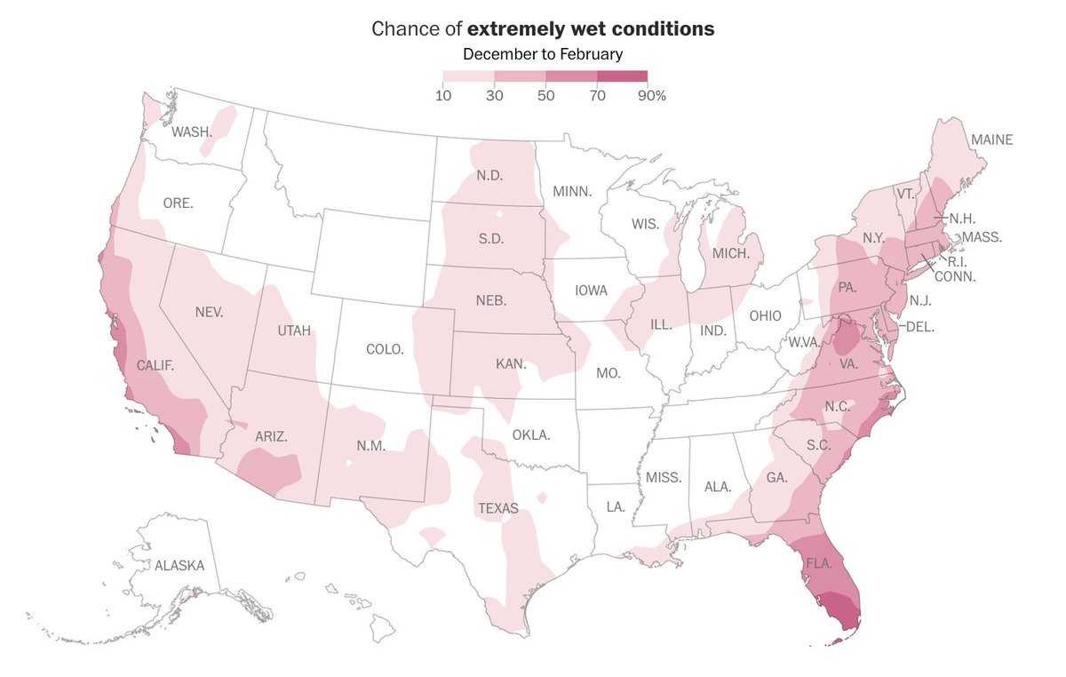
If you live in a pink area on this map, your chances for a particularly stormy winter are notably higher than normal.

That includes densely populated stretches of the West and East!

I surveyed meteorologists from these regions. Here's what they said 🧵

If you live in a pink area on this map, your chances for a particularly stormy winter are notably higher than normal.
  • 611 likes
  • 87 reposts
  • 19 replies
  • 86,639 views
View on X

Watching the potential for a sudden stratospheric warming event in early November 👀

The key will be whether its effects couple downward into the troposphere, where they could alter weather patterns. So far, there's no clear sign of that happening.

  • 282 likes
  • 44 reposts
  • 12 replies
  • 25,335 views
View on X

As an El Niño-fueled subtropical jet stream roars to life, a surge of Pacific moisture up to 3x normal levels is poised to reach the U.S. in early November.

This could bring more flood threats to the West, severe weather to the central states and warmth to the East.

  • 361 likes
  • 88 reposts
  • 6 replies
  • 21,566 views
View on X

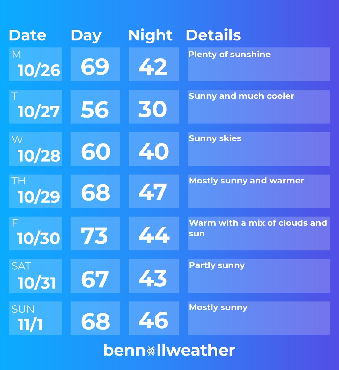
Treats, not tricks, for the #HudsonValley this week 🎃

The Hudson Valley’s dry streak looks likely to continue this week, as sunshine remains abundant with a mix of crisp mornings and warmer afternoons.

A cold front will push through the region on Monday night, leading to cooler weather on Tuesday and Wednesday, followed by more warmth, especially on Friday.

If it doesn’t rain through Halloween, the region’s dry streak would reach two weeks. Every day beyond two weeks becomes more statistically uncommon around here. Dry stretches as long as this one don’t come around too often!

A storm system could gather to the west of the region next weekend, although the chances for rain on Saturday and/or Sunday don’t look high enough to mention in the forecast at this point.

Also, right now, Halloween is looking comfortably warm.

Looking ahead to early November, there are signs of more mild weather, though rain chances are expected to increase. That’s because of an active jet stream pattern from El Niño.

That’s another reason to enjoy the current calm conditions — because they won’t last.

I’m expecting quite a stormy winter across the region, which you can read all about in my winter outlook, which was just released yesterday: bennollsays.com/p/hudson-valley-winter-outlook-2026

I’ll keep this update short and charge my batteries for the busy season ahead ✌️

Treats, not tricks, for the #HudsonValley this week 🎃